La Palma Airport (SPC)
City Orientation and Maps
(La Palma, Canary Islands, Spain)
La Palma is one of the Spanish Canary Islands and is surrounded by the Atlantic Ocean. La Palma is smaller and quieter than the more popular islands of Fuerteventura, Gran Canaria, Lanzarote and Tenerife, all of which lie to the east. The islands of Gomera and Hierro and both located to the south of La Palma.
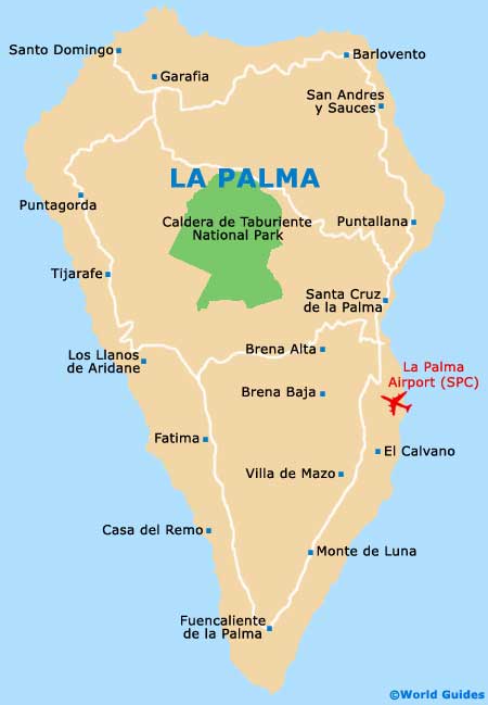
The island itself contains many places of interest, with a number of popular towns, villages and resorts dotted along the coastline. Santa Cruz de La Palma is the capital of the island and is the only large town. Brimming with historic buildings, Santa Cruz is situated north of La Palma Airport (SPC). Highlights within the town include many cobbled streets, small local stores and a mountainous backdrop contains hill-side villages bordered by white walls.
La Palma Airport (SPC) Maps: Important City Districts
Other places of interest on the island of La Palma include Playa Nueva, a new beach area just 1 km / 0.5 miles to the south of Santa Cruz and within walking distance of the town centre. Further south you will find a number of attractions, all of which can be easily reached along straight roads, such as the LP-1 Highway, leading the Los Cancajos - a small cove with a charming volcanic beach. Also nearby, the village of Mazo is around 13 km / 8 miles south of Santa Cruz de La Palma and is surrounded by lush, dormant volcanoes.
On the western side of La Palma, both Puerto Naos and Puerto de Tazacorte are popular communities. Puerto Naos actively welcomes tourists and is home to a dark sandy beach, peppered with palm trees, while Puerto de Tazacorte is known for its brightly coloured houses, narrow streets and long stretch of sand.
Spain Map

La Palma Map